Ici, nous allons voir un cas d'étude bien particulier relatif à une chaîne de traitement raster visant à constituer de manière automatisée un ensemble de dalles cadastrales sur la région PACA, soit 963 dalles (car 963 communes).
samedi 31 décembre 2011
[fr] Talend Chef d'Orchestre d'un Traitement Raster: Découpage du Cadastre par Commune
Ici, nous allons voir un cas d'étude bien particulier relatif à une chaîne de traitement raster visant à constituer de manière automatisée un ensemble de dalles cadastrales sur la région PACA, soit 963 dalles (car 963 communes).
samedi 19 novembre 2011
[Feed #3] Data scientists, IKEA heat map, GDEM Aster, MapQuest Elevation Service, Spatial models of Peace, GeoKettle, and other things
mercredi 2 novembre 2011
[fr] Journée QGIS - OSGEO 2011
 Il y a une semaine, le MEDDTL a abrité sous son Arche la journée OSGEO 2011 consacrée à l'outil Quantum GIS.
Cet évènement a une teneur symbolique puisqu'il témoigne de l'intérêt que portent les Ministères de l'Ecologie (MEDDTL) ainsi que de l'Agriculture (MAAPRAT) pour le logiciel libre en géomatique
Il s'agit probablement de la journée OSGEO qui a compté le plus d'agents du Ministère.
vendredi 14 octobre 2011
On the road with R & Grass: Intervisibility along Lines
vendredi 23 septembre 2011
[Feed #2] PostGIS 2.0, WPS Shoot-out, Spatial Analysis, GeOps or easy editing with OpenLayers,...
Spatial Analysis
Here is a very good and complete resource I found dealing with different aspects of spatial analysis.>> http://www.spatialanalysisonline.com/output/
A scientific article about topological models and frameworks for 3D spatial objects
>> http://www.gdmc.nl/zlatanova/thesis/html/refer/ps/sdarticle.pdf
Softwares
Spatial Business Intelligence is gaining a lot of interest as more and morevendredi 16 septembre 2011
Feed #1 foss4G, OpenAerialMap, QGIS & GvSIG,...
Events
- FOSS4G, a major event for the Open Source GIS World. A little review here
>> http://slashgeo.org/2011/09/15/FOSS4G-2011-OpenData-OpenLayers-Mobile-Nodejs-Mapnik-OpenAerialMap
- Web services, clouds...but no need to buy a plane to reach them...During FOSS4G, a nice application has been presented implementing WPS (Web Processing Service) through the implementation of ZOO API project. It gives an idea of the dynamics of web GIS applications development and the possibility of realizing some web apps that are similar to desktop ones
>> http://www.mapmint.com/index.php?page=mapmint-modules
lundi 16 mai 2011
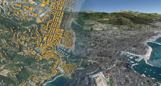
[R] Buildings on Google Earth : from 2D to 3D
 As I discover the marvels of (geo)R world, I found out this article (link)
It explains how to generate KML files from meuse, the source dataset delivered with sp package, using R software.
In the tutorial, KML files are created from scracth, writing each line of it.OGR driver only gives access to the options name and description (rdgal driver). So, "brute coding" may be necessary if you want to control other elements: color, heights for extruded objects...
Many people would like to visualize some buildings in 3D in google. The reference data that we have for buildings is often plain but there usually is a column specifying the height of each building. For example, for the french BDTOPO, the HAUTEUR column.
Inscription à :
Commentaires (Atom)


